Rotterdam region
Spatial adaptation is vitally important for a low-lying delta region in order to remain safe and attractive in the future as well. The City of Rotterdam has already launched an adaptation strategy, in October 2013, and for several years has been a world leader in the field of climate adaptation. The surrounding municipalities are now also taking action, starting with several climate adaptation quick scans. Using a stress test lite, they are mapping out opportunities and taskings, thus gaining insight into where action is needed.
Analysis – Climate Impact Atlas
A climate impact atlas has helped identify what the region may expect in terms of pluvial flooding, flood risk management, heat, drying out and salinisation. For example, the heat image below shows that the entire region is headed for an increasing number of hot summer nights.
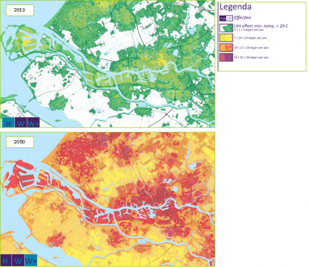
The above images have been derived from the Regional Climate Atlas and indicate the number of days with a minimum temperature of 20 °C. The top figure reflects the current situation. The bottom figure reflects the situation in 2050 under the W+ scenario. Urbanised areas are already experiencing significantly more hot and tropical days than are rural areas. In 2050, however, the temperature will rise considerably outside the cities as well. In the W scenario, the number of hot and tropical days will rise to 38, in the W+ scenario to 50.
Analysis – stress test lite
The climate impact atlas demonstrates that “something is going on”. The next question is where the local taskings and opportunities are to be found. For that reason, several municipalities have initiated a climate adaptation quick scan, similar to a stress test lite, in order to link the model images of the climate impact atlas to everyday practice. The scan examines questions such as: Where do residents and companies already experience problems? What (spatial) developments are taking place that climate adaptation can tie in with or even provide with added value? What smart combinations can be made between policy fields such as spatial planning, green issues, the environment, water, the economy, and health?
Ambition – Goals and ambitions
All the municipalities are focusing on the continued existence of the region, and on enhancing its appeal. Most municipalities also have explicit ambitions in the fields of sustainability, habitability, health, and/or the economy. In addition, the City of Rotterdam has expressed concrete ambitions relating to climate adaptation, viz.: “Rotterdam Climate-Proof by 2025”. Most other municipalities await the climate adaptation quick scan in order to set down their ambitions. In this respect, it is important for climate change and climate-proofing to be integrated into other policy fields, rather than viewing climate adaptation as a separate policy field.
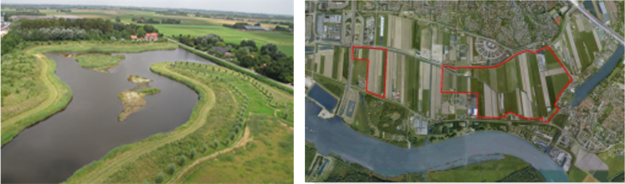
Examples of climate adaptation: Hellevoetsluis Grasweg area (left): combination of peak water storage and Nature development. Zuidpolder Barendrecht climate buffer (right): combination of freshwater storage, Nature, and recreation.
Action – Seizing opportunities and linkage
One of the conclusions of the quick scan conducted in the municipality of Schiedam is that various climate-proofing activities have already been carried out without having been designated as such. For example, peak water storage has been created beneath the Parallelweg road surface, visitors and residents are enjoying trees full of Rose-Ringed Parakeets, while the city ecologist has for years been factoring in the incidental influx of saline water when selecting greenery for a park located outside the dykes. Elsewhere in the region, various other climate-proofing projects have been carried out, such as introducing green rooftops (e.g., on the Capelle a/d IJssel and Barendrecht town halls), or the construction of peak water storage in combination with Nature development (Zuidpolder in Barendrecht, and the Grasweg area in Hellevoetsluis).
By the end of 2014, we will have more clarity regarding the other prospects for climate-proofing the region. The results of the quick scans conducted in all (!) the municipalities of the urban region will then be available. Furthermore, we will then know how the Schiedam quick scan has provided input for a concrete climate adaptation strategy.
1: In 2014, Stadsregio Rotterdam comprised the following municipalities: Maassluis, Vlaardingen, Schiedam, Lansingerland, Krimpen a/d IJssel, Capelle a/d IJssel, Ridderkerk, Barendrecht, Albrandswaard, Spijkenisse, Brielle, Bernisse, West-Voorne, Hellevoetsluis, and Rotterdam.
Contact Person
Lissy Nijhuis
Project leader, Rotterdam Region Adaptation Strategy
Stadsregio Rotterdam / City of Rotterdam
Ewjt.nijhuis@rotterdam.nl