Vierde Bergboezem Breda natural climate buffer
The Vierde Bergboezem nature reserve and recreation area is located north of the city of Breda. Since 2010 it has served as a water storage area that helps to protect the Breda centre against flooding. Any excess water flowing through the Mark in Breda during extreme downpours can be temporarily stored in the Vierde Bergboezem.
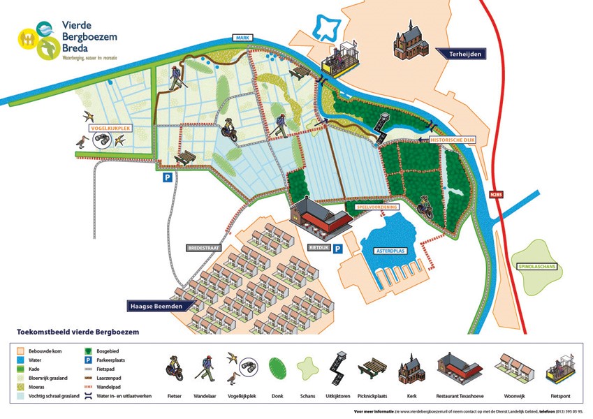
What type of area is the Vierde Bergboezem?
The Vierde Bergboezem spans 276 hectares and comprises the subsections of Hooijdonk, Werft, Lange Bunders, Slangenwijk, Molenpolder, and Buitendijks Slangenwijk. It features various types of landscape, such as quagmired grassland, moist meadowland, swamps, and restored river dunes. These river dunes are referred to as “donks”. The Brabantse Delta district water board, the province of Noord-Brabant, the municipality of Breda, and Staatsbosbeheer [Dutch government organisation for forestry and management of nature reserves] have joined forces to create a water storage area in which herbs and flowers grow, and which is home to a wide variety of wildlife. In the development process, they have capitalised on the area’s rich cultural history, such as the seventeenth-century line dykes.
What measures have been taken?
In order to convert the Vierde Bergboezem into a water storage area, the parties have taken the following measures:
- They have constructed an embankment, which has enabled the development of a new overflow area with a secondary channel along the river Mark. This secondary channel boosts biodiversity in terms of plants and wildlife.
- A secondary channel has also been constructed in the Molenpolder and Buitendijks Slangenwijk sections. This secondary channel accommodates the water storage inlet structures. Inlet structures are a type of sluice that enables control over the water flowing into and out of the area.
- In the Lange Bunders and Slangenwijk sections, ditches were filled in and upper layers were excavated in order to increase the moisture content of the soil. New channels will also be dug, which will boost moisture in the area as well as its biodiversity. The goal is to redesign the landscape, wherever possible, similar to its appearance in the days before the land consolidations, in order to restore its connection with the past.
- Cycle paths, footpaths, and hiking trails have been created to increase the area’s appeal for visitors.
- A part of the area features grass that is used for hay; the other part is grazed.
What results have been achieved?
Prior to 2010, three water storage areas helped to protect the city of Breda against flooding which occurs once every fifty years: Weimeren, Rooskensdonk, and Terheijde. The Vierde Bergboezem ensures that Breda is also protected against flooding that occurs once every one hundred years. Furthermore, the Vierde Bergboezem area accommodates the Haagse Beemdenbos forest. The intention is for this forest to eventually develop into a marshy forest which is prone to flooding and which will attract more amphibians, beetles, and birds.
Forest playground contributes to Play Action Plan
In 2014, the parties also created a forest playground for children, just outside the Vierde Bergboezem area: Brakkenbos. This tied in with the Play Action Plan of the municipality of Breda, which aims to create more locations in the natural environment where children can play.
Contact person
Jan Janse
06 - 51 42 40 21
j.janse@staatsbosbeheer.nl