Dongen climate workshop
The climate workshop was intended to gain insight into the effects of climate change on the living environment in the municipality of Dongen, and the interconnectivity of the various climate issues, the water system, and spatial planning. The workshop involved a “stress test light”: insight into the tasking with which the parties are faced, and recommendations regarding subsequent steps, based on knowledge and information currently available. In essence, the climate workshops focus on the four themes set out in the climate impact atlas: flood risk management, pluvial flooding, drought, and heat. Flood risk management is not an issue for the municipality of Dongen, which is why it has been left out of consideration.
Process
The climate workshop was structured as follows:
- During an intake meeting, the participants have exchanged their views regarding the purpose and scope of the workshop. In addition, they have drawn up a draft schedule and a list of individuals and organisations to be invited. They have also set down agreements regarding the exchange of information.
- The actual climate workshop was held on 8 June 2016.
- The workshop was evaluated on 5 July 2016.
In preparation for the climate workshop, basic maps have been drafted for the three relevant climate issues, indicating the climate effects to be expected (see Appendix B to the downloadable PDF document). These maps have been discussed during the workshop. The information contained in the maps has been assessed for completeness and relevance to the municipality. The discussions on the basic maps have been summarised into a vulnerabilities map, indicating the locations at which the municipality of Dongen is vulnerable to climate change, and the issues that may come into play.
Results
The climate workshop has generated the vulnerabilities map below.
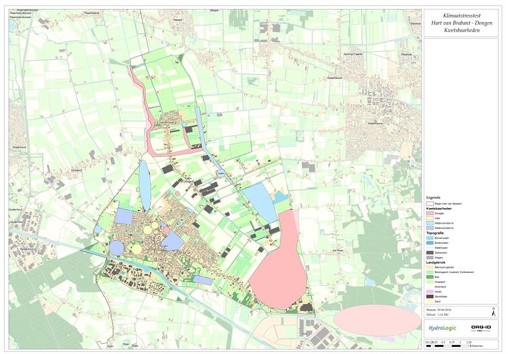
During the climate workshop, we discussed the climate issues. The main comments and vulnerabilities are:
Knowledge issues and development
- How will changing groundwater levels impact a number of specific locations, such as cemeteries and the area in the north-western urban region of Dongen (between Beljaartlaan and Procureurweg)?
- In the future, the expectation is that elderly people will continue to live at home or with relatives for a longer period of time. As a result, the municipality tends to lose track of this group. A point for attention is how the municipality can nonetheless reach this group.
- How will the air quality change if the urban area is warming?
Climate impact
- Flooding from creek water during T100 downpours is an issue in rural areas, but not in urban areas.
- The map identifies a number of urban locations prone to pluvial flooding following severe precipitation. In addition, it identifies a location featuring negative sewer overflows.
- The capacity of the culverts in the ’s Gravenmoerse Vaart and Dongense Vaart is insufficient. As a result, these canals are already prone to backwater, which occasionally causes problems. One such problem is that the water cannot be discharged at a greenhouse farm that drains into these canals. This causes flooding at this farm’s premises.
- Groundwater flooding is currently not an issue. The north-western part of the Dongen urban area is slightly wet, but this is not perceived as a nuisance.
- The district water board regulates the water level of the peat area in the northern part of the municipality, which reduces drought problems. This peat area is surrounded by dykes with cultural-historical trees.
- The map identifies a number of pools that are prone to running dry.
- In the agricultural area in the south-eastern part of the municipality, a 30-cm drop in groundwater will cause irrigation problems.
- Drought will cause the wet “De Rekken” nature reserve to dry up.
- If the groundwater level falls, so will the water level in the ponds in the urban area. This will affect the water quality and the liveability. The map identifies a location that is currently affected by blue-green algae. This may harm public health.
- The Lobelia nature reserve is an important source of water supply for the farm sector in the municipality of Dongen. The nature reserve is not located within the municipality of Dongen, but rather in the municipalities of Loon op Zand and Tilburg. If it dries up, it could affect the water supply from the ditches in the southern part of the municipality, which would impact the farm sector.
- The map identifies a number of locations vulnerable to heat, such as nursing homes and the “Pukkemuk” petting zoo.
- The urban area features a “green lung”, i.e., an area with an abundance of greenery. This is important with a view to (combating) heat stress.
More details on the conclusions and recommendations are provided in the document pertaining to this practical example.
Contact person
Albert Elshof
ORG-ID
06 53 66 18 69
elshof@org-id.org