Gilze en Rijen climate workshop
The climate workshop was intended to gain insight into the effects of climate change on the living environment in the municipality of Gilze en Rijen, and the interconnectivity of the various climate issues, the water system, and spatial planning. The workshop involved a “stress test light”: insight into the tasking with which the parties are faced, and recommendations regarding subsequent steps, based on knowledge and information currently available. In essence, the climate workshops focus on the four themes set out in the climate impact atlas: flood risk management, pluvial flooding, drought, and heat. Flood risk management is not an issue for the municipality of Gilze en Rijen, which is why it has been left out of consideration.
Process
The climate workshop was structured as follows:
- During an intake meeting, the participants have exchanged their views regarding the purpose and scope of the workshop. In addition, they have drawn up a draft schedule and a list of individuals and organisations to be invited. They have also set down agreements regarding the exchange of information.
- The actual climate workshop was held on 3 June 2016.
- The workshop was evaluated on 5 July.
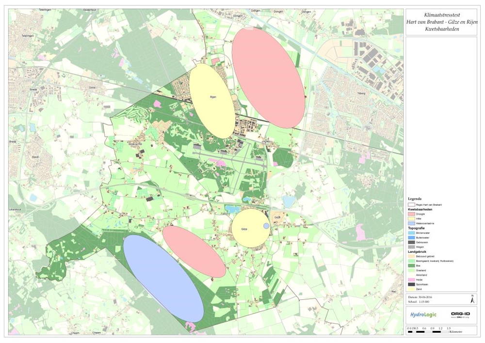
In preparation for the climate workshop, basic maps have been drafted for the three relevant climate issues, indicating the climate effects to be expected (see Appendix B to the downloadable document). These maps have been discussed during the workshop. The information contained in the maps has been assessed for completeness and relevance to the municipality. The discussions on the basic maps have been summarised into a vulnerabilities map, indicating the locations at which the municipality of Gilze en Rijen is vulnerable to climate change, and the issues that may come into play.
Results
The climate workshop has generated the vulnerabilities map below.
During the climate workshop, we discussed the climate issues. The main comments and vulnerabilities are:
Knowledge issues and development
- Would it be possible to transfer the sewer system drainage from Kerkstraat in Gilze to the outskirts?
- How will drought impact the “Schier” forest area and the open landscape? In the past, a diminishing water supply has already affected the vegetation in this forest area; will this happen again in the future?
- The loam deposits in the subsoil hinder the infiltration of (rain) water. What options are there to infiltrate water nonetheless?
Climate impact
Flooding
- The map identifies a number of locations affected by excessive sewer system pressure. These locations have flooded in the past. In addition, several other locations have seen water-in-the-street situations.
- In a number of houses within the municipality, the floor level is too low, which causes groundwater flooding.
- The retention area north-east of Rijen served its purpose during the downpours in early June. However, some sewer overflow water was discharged over land, which was not intended.
- A rainwater discharge connection is located between a section of the urban area and the Ecological Connecting Zone. This discharge must be taken into account in the future urban development that is scheduled here.
- The northern section of the municipality of Gilze en Rijen is quite wet. During a T100 downpour, many locations here will be flooded by brook water. Several maize fields in the area are vulnerable to such flooding.
Drought
- Brooks currently account for only a small proportion of the water supply to farmlands. Nearly the entire water supply is derived from groundwater.
- Drought may create a more favourable habitat for exotic species such as other mosquitos and the processionary caterpillar in the Netherlands. Several locations on the map have been marked with blue-green algae.
- The municipal water supply is collected from a deep aquifer. Any future change in groundwater level will hardly have any impact.
- The municipality comprises many sections of loamy soil. Groundwater is present above the loam deposit, but this groundwater is depleted by mid-July. The expectation is that this groundwater will be depleted even sooner in the event of falling groundwater levels or a change in precipitation patterns.
Heat
- In the city centre, trees tend to make way for paving.
- The increasing heat provides an opportunity for generating (more) energy.
More details on the conclusions and recommendations are provided in the document pertaining to this practical example.
Contact person
Albert Elshof
ORG-ID
06 53 66 18 69
elshof@org-id.org