Waalwijk climate workshop
The climate workshop is intended to gain insight into the effects of climate change on the living environment in the municipality of Waalwijk, and the interconnectivity of the various climate issues, the water system, and spatial planning. The workshop involves a “stress test light”: insight into the tasking with which the parties are faced, and recommendations regarding subsequent steps, based on knowledge and information currently available. In essence, the climate workshops focus on the four themes set out in the climate impact atlas: flood risk management, pluvial flooding, drought, and heat.
Process
The climate workshop was structured as follows:
- During an intake meeting, the participants have exchanged their views regarding the purpose and scope of the workshop. In addition, they have drawn up a draft schedule and a list of individuals and organisations to be invited. They have also set down agreements regarding the exchange of information.
- The actual climate workshop was held on 30 May 2016.
- The workshop was evaluated on 5 July.
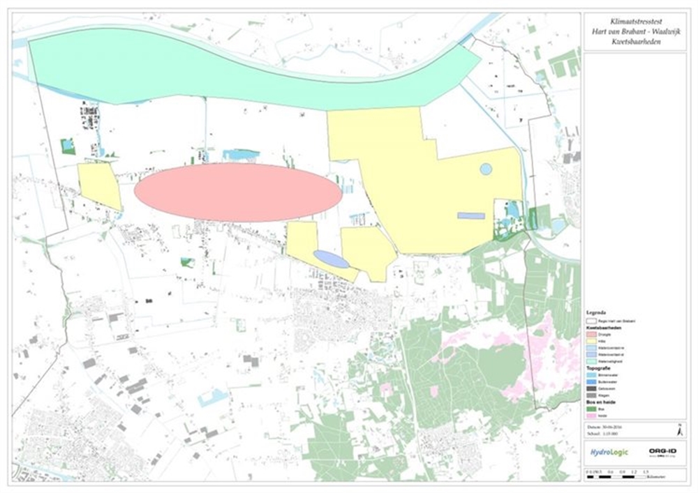
In preparation for the climate workshop, basic maps have been drafted for the three relevant climate issues, indicating the climate effects to be expected (see Appendix B to the downloadable document). These maps have been discussed during the workshop. The information contained in the maps has been assessed for completeness and relevance to the municipality. The discussions on the basic maps have been summarised into a vulnerabilities map, indicating the locations at which the municipality of Waalwijk is vulnerable to climate change, and the issues that may come into play.
Results
The climate workshop has generated the vulnerabilities map below.
During the climate workshop, we discussed the climate issues. The main comments and vulnerabilities are:
Knowledge issues and development
- As yet, little is known about the changes in groundwater level. Several locations are currently prone to wet basements. The question is how this will change in the future.
- In the future, nursing homes may close and elderly people will continue to live at home or stay with relatives. How can this group of residents be targeted with heat plans?
Climate impact
Flood risk management
- In addition to the Meuse flood defence system, river water is held back by several regional flood defence systems. The motorway also serves as a flood defence system.
- The elevation of the Waalwijk urban area is lower than that of the polder between the river Meuse and the urban area. Consequently, failure of all the flood defence systems will definitely impact the urban area.
- In the future, the flood defence systems will need to be raised. This will impact the area around the dykes. In concrete terms, this will affect the eastern section of the Waalwijk urban area, and a distribution station located close to the dyke. The improvement of the flood defence systems is scheduled for around 2030.
- Potential escape routes have been indicated on the map, with a bottleneck near the approach road to the N261 motorway.
Flooding
- The south-eastern section of the Waalwijk urban area is prone to underseepage flooding. This area also accommodates a key water collection plant; this must continue to operate in order to combat such flooding.
- Flooding from brooks is currently not an issue.
- Several locations in the urban area are prone to pluvial flooding. Several of these have been marked on the map. The municipal authorities have compiled an impact map for downpour categories 8 to 10.
Drought
- The areas whose water supply is covered by the district water board are not prone to drought and will probably remain unaffected by drought.
- In addition, last year an option was developed to regulate the water level in the south-eastern section of the Waalwijk urban area by supplying water from a pool. This is important, because this section of Waalwijk is prone to major fluctuations of the groundwater level in the upper layers.
- The industrial estate north of Waalwijk is currently affected by drying pools in the ecological connecting zone. Ditches in the urban area are also running dry.
- A large underseepage area is located between Waalwijk and Waspik. A fall in underseepage as a result of drought will have a negative impact on Nature.
Heat
- Densely built-up areas (e.g., terraced houses) have more warmer nights than neighbourhoods with many detached houses and greenery.
More details on the conclusions and recommendations are provided in the document pertaining to this practical example.
Contact person
Albert Elshof
ORG-ID
06 53 66 18 69
elshof@org-id.org