Impact project: Climate-proof and Sustainable Development tool
How can you make your home and garden climate-adaptive, energy-efficient, whilst at the same time enhance their appeal to flora and fauna? And what sustainable materials can be used to this end? The municipality of Gooise Meren has amassed expertise and information, and has developed a comprehensive construction policy. The process has generated two user-friendly tools, for residents and for construction professionals.
Comprehensive construction policy
The municipality of Gooise Meren is seeking sustainable ways to develop its physical environment. For that reason, it is drawing up a comprehensive construction policy, focused on the issues of climate adaptation, energy transition, biodiversity, and circularity.
In this impact project, policy makers have joined forces with local (construction) parties and residents to map out the taskings and opportunities. The results have been used to develop two tools: a tool for residents and a tool for construction professionals. The process and the substantive analyses have been supported by the Dutch Institute for Building Biology and Ecology NIBE, Wageningen University, Atelier GroenBlauw, and the Climate Adaptation Services foundation (CAS).
Area-oriented approach
Efficiently drawing up sustainable construction policy requires insight into the local characteristics of a municipality. The fact is that in many cases, both the taskings and the solutions will be location specific. For example, clayey soil is more prone to waterlogging than is sandy soil. And in a residential area constructed in the 1930s, insulating houses will be quite an improvement, whereas in new housing estates, placing solar panels will be more effective. That is why risk and opportunity analyses have been conducted with respect to each of these issues.
Taskings and opportunity analyses mapped out
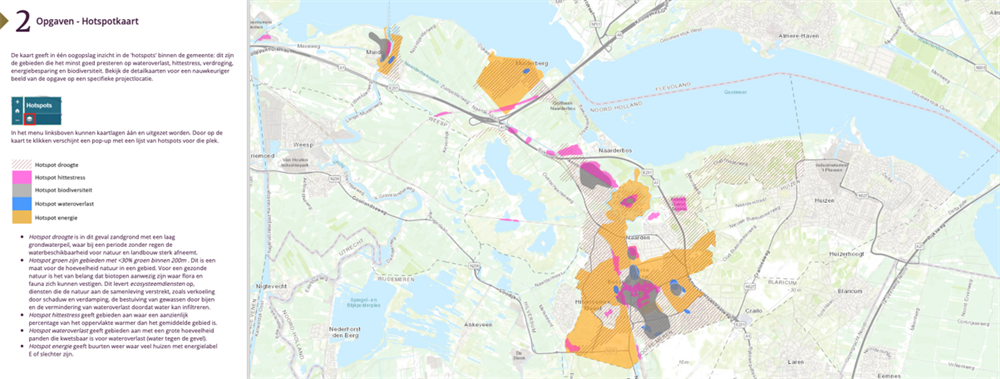
- The issue of climate adaptation was addressed on the basis of the stress test that had already been conducted. Input was taken from the waterlogging and heat stress maps generated in this test. Wageningen University conducted a soil and subsoil analysis. This analysis provides insight into two issues: which areas are prone to drought, and which strategy holds promise for which location in terms of preventing waterlogging?
- With respect to the energy transition issue, the building tasking within the municipality was considered. The energy label provides information regarding a building’s energy performances.
- The issue of circular construction was assessed primarily on the basis of the opportunities for new construction projects and for renovations within existing buildings. This is where the majority of opportunities for a circular approach can be found.
- In the purview of the biodiversity issue, relevant icon species were mapped out for each type of neighbourhood, and the volume of greenery within the municipality was assessed.
Opportunity analyses: strategies and measures
In addition to the map analyses, potential measures were listed for each issue. These measures were categorised into comprehensive “strategies”, underpinned by similar principles for tackling a tasking. Furthermore, it was assessed whether specific measures and strategies for each issue had ground in common, or conversely, whether they clashed with those identified for other issues. Such knowledge supports the comprehensive consideration of pros and cons.
Exploring taskings and opportunities in concert with local parties
The decisions regarding the direction of the tools and the policy were taken by a core team comprising policy consultants responsible for all the issues involved. In addition, during the entire process, a consultative group provided input and feedback via meetings and via email, in terms of content (what information must be taken into account?) and in terms of format (what must the tools look like?). This consultative group was composed of representatives of municipal residents (via the Samen sneller duurzaam [Collectively Expediting Sustainability] working group), of construction professionals, and of representatives of the sustainable construction desk, the district water board, and the regional authorities. During each consultative group session, the (interim) results of the analyses and tools were discussed, validated, and supplemented together with the parties involved.
Insight in the purview of construction policy
The analyses provided the policymakers with insight into the issues at play within the municipality and the locations involved. “Hotspots” were identified in concert. On the basis of the analyses, the policymakers are now drafting construction policy. Until such policy has been completed, the municipality will be focusing on raising awareness among the initiators of renovation, construction, and development projects. Two tools have been developed to this end: one for residents and one for construction professionals, such as housing corporations and developers.
Tool for residents
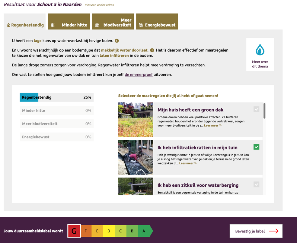
An accessible and user-friendly website has been built for residents, which enables them to compose their own set of measures in a playful manner. A resident must first provide his or her home address. Subsequently, the tool indicates which issues are at play there: is this address prone to waterlogging? What is the situation in terms of local biodiversity? The resident can then tick off measures. For each measure selected, score bars indicate how the measure fosters sustainability. For example, a green roof helps to reduce waterlogging and heat stress, and provides better insulation of the house. The measures that the resident is actually going to implement can be stored, along with a photo if so desired. This enables the resident to view the measures that have already been taken in the neighbourhood.
Tool for construction professionals
The point of departure underpinning the tool for construction professionals is that it is best left to the professionals themselves to decide how they wish to address a tasking. That is why, rather than imposing a ready-made set of measures, the tool provides insight into potential strategies that can be implemented with various measures. The fact is that in many cases, construction professionals command the know-how and capacity themselves to design the most appropriate solution. The tool will be available on a website and makes the professionals aware of the risks and opportunities in two steps:
- Step 1: the professional uses the map analysis to explore the taskings at play at the project location;
- Step 2: the professional explores the strategies available for the taskings at play at the project location. The professional is challenged to opt for strategies that foster multiple sustainability issues.
There is no information yet on the release date of the professional tool.
Involvement of residents
The consultative group sessions were well attended by the working groups of the Samen sneller duurzaam residents initiative. The commitment and involvement of these working groups has boosted the formulation of locally relevant policy.
Lessons to be learned
This project supports the formulation of comprehensive construction policy, with the participation of local and regional parties. This chimes with the new approach as prompted by the Environment Act. This way of combining issues within policy and in a comprehensive instrument does not constitute “business as usual”. We have learned that it requires additional time and attention with respect to the following factors:
1. Raising awareness among parties involved
The combination of energy transition, climate adaptation, biodiversity and circularity issues entails the involvement of multiple experts and fields of expertise both within and outside the municipality. The identification of relevant ground in common and clashes between these issues first requires that the experts are brought up to date regarding all the issues: which issue is relevant at which location? What are the major considerations? What are the underlying mechanisms and where are the greatest opportunities to be found? And how does all that relate to someone’s personal expertise? It is recommended, upon rolling out the project, that one or two sessions be devoted to the “internalisation” of the various issues and the considerations to be made. For example, such sessions may be substantiated in a workshop format, based on the outcomes of an initial risk and opportunity analysis. During this project, this step has taken up more time than originally planned for.
2. Participation of relevant parties
In addition to a diversity of issues, the substantiation of the policy and tools has involved a diversity of parties, i.e., a multitude of expertise, requirements, and ideas. This broad involvement provides insight into which information is already available for the municipality to elaborate on. The consultative group sessions were all scheduled at the end of a working day (during the sessions, soup and sandwiches were served!). These evenings were well attended. In small working groups, the participants brainstormed on the design of the tools, the functionalities they should feature, and the information that was required. In concert with the core team, the outcomes were categorised into “can be taken up now”, “will be explored”, and “still in the future”. This creates transparency regarding what is taken up and what is left until a later date.
3. A policy assessment framework
How can the importance of the energy transition, climate adaptation, biodiversity, and circularity be weighed at a project location? And what determines the scope of the efforts to be expended regarding each of these issues? Based on the map analysis, the policy makers identified “hotspots” for each issue. A hotspot signifies a great potential for improvement. Some municipal locations feature multiple hotspots, whereas others are faced with fewer taskings. The hotspots constitute leads for the policy focus at that location and for the scope of the work to be done there. If a project location is faced with but a single tasking, all the efforts can be focused on this issue and the municipality may expect maximum ambition. However, if a project location features multiple taskings to be tackled, expecting a maximum ambition for each issue is not always realistic. In such cases, the municipality may choose to request a minimum ambition for each of the issues. The municipality is currently defining the various ambition levels. This is substantiated in a score system, in which different efforts are rewarded with different scores. The determination of such scores poses a major challenge.
4. Policy, communication, and supporting tools
The amassing of information and expertise does not automatically result in consensus regarding the direction and substantiation of policy, nor in consensus regarding the manner in which such policy must be communicated to those involved via tools. The tools that have been developed during the project have supported the awareness process (lesson to be learned 1), the involvement of parties (lesson to be learned 2), the formulation of an assessment framework (lesson to be learned 3), and the presentation of a desired strategy to communicate such policy to the intended target groups: residents and construction professionals. The following strategies have been drawn up to this end:
- Residents: the map analysis and the lists of measures have been converted into an extremely user-friendly tool and website, which automatically generate measures. Rather than displaying complicated risk maps, the emphasis is on ways to enhance the appeal, health, and sustainability of homes and gardens. And on ways to help keep the neighbourhood comfortable and liveable, and to involve neighbours in these efforts.
- Construction professionals: the map analysis and list of strategies are initially made available to raise awareness. Once policy is ready, the map tool will, in an interactive manner, indicate what is expected from a construction professional at a project location.
On the basis of these strategies, the requirements to be met by these tools have been reviewed. This revealed that the tools developed need to be restructured in terms of content (the route via which the end user is guided through the information) and in terms of format (full implementation of the municipal communication house style).
5. Information management and updating
Stocktaking of the information available for the risk and opportunity analyses quickly revealed that the amount of spatial information available differs from one tasking to the next. For example, the circularity issue offers fewer options for demonstrating opportunities and taskings at a project location than do the adaptation, energy, and biodiversity issues. However, the latter three issues are also bound by limitations. Not all the information is available or available at the appropriate time. It is important to be transparent regarding the information used, and to make agreements regarding the updating and management of the information and the tools. For example, in 2020, an extensive biodiversity analysis and a heat vision will become available for the municipality. This information will be integrated into the tools.
Contact person
Antionette Soede
Gemeente Gooise Meren
a.soede@gooisemeren.nl