State of your Street climate label
A climate label for every street in the city, that is what “State of your Street” advocates. Government authorities are actively committed to climate adaptation. Private property accounts for some 60 per cent of urban surface area. This means that the implementation of measures such as more greenery, disconnecting downspouts, and rainwater infiltration requires the support of local residents. As climate information is largely technical in nature, residents often have difficulty imagining the situation in their streets. “State of your Street” aims to remedy this by presenting data at a scale level that appeals to residents: a climate label for their own street.
Results
The State of your Street pilot conducted in Rijssen-Holten has resulted in an interactive tool that presents the “State of your Street” label in a web portal. The tool has provided the municipality of Rijssen-Holten with insight into vulnerable areas, which has contributed to the formulation of its ambitions. In addition, the tool has created awareness of climate issues within the municipal organisation.
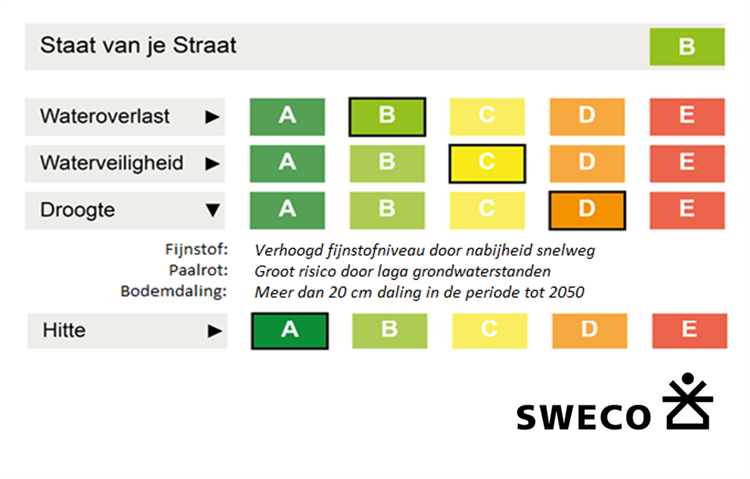
The “State of your Street” label is determined on the basis of indicators relating to the issues of urban flooding, waterlogging, drought, and heat. The indicators are used to assess each street in terms of these four issues; on the basis of the assessment, a label is awarded ranging from label A (highly climate-adaptive) to label E (hardly climate-adaptive). Subsequently, these labels are presented in the portal. Users may select streets to further examine the assessment for each theme.
The “State of your Street” assessment is initially set up on an open data basis. Subsequently, a more accurate label may be developed based on local data, for example, by linking the label to information on the management of the living environment as is available in management packages such as Obsurv. With respect to waterlogging, the results of various models may be used.
Lessons to be learned from the project
- Use existing information, to be supplemented wherever necessary. A great deal of open data on climate adaptation is already available. By bundling this information and simplifying its interpretation, State of your Street will help to raise awareness.
- A simple label will provide users with rapid insight into a street’s condition. This is particularly helpful for those not accustomed to working with maps. This insight will boost the sense of urgency to embark on climate adaptation.
- Use a transparent standard for setting down goals. Municipalities are faced with the challenge of determining how they wish to climate-proof their territory. State of your Street helps to concretize this by presenting transparent standards.
Contact person
Martijn Steenstra
Sweco
Martijn.steenstra@sweco.nl
06-22 37 17 91